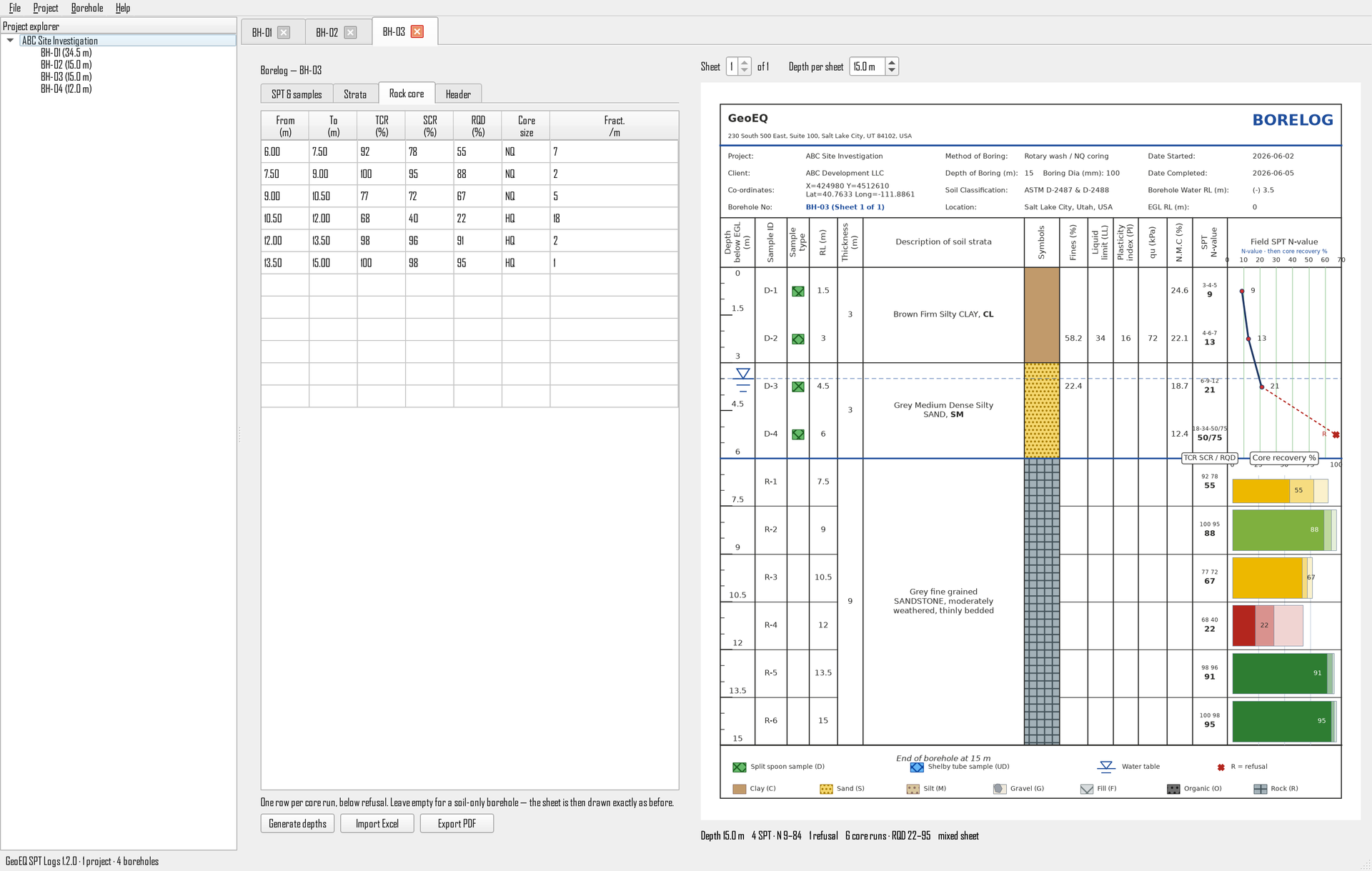
01 · Enter and review
The borelog redraws as you type
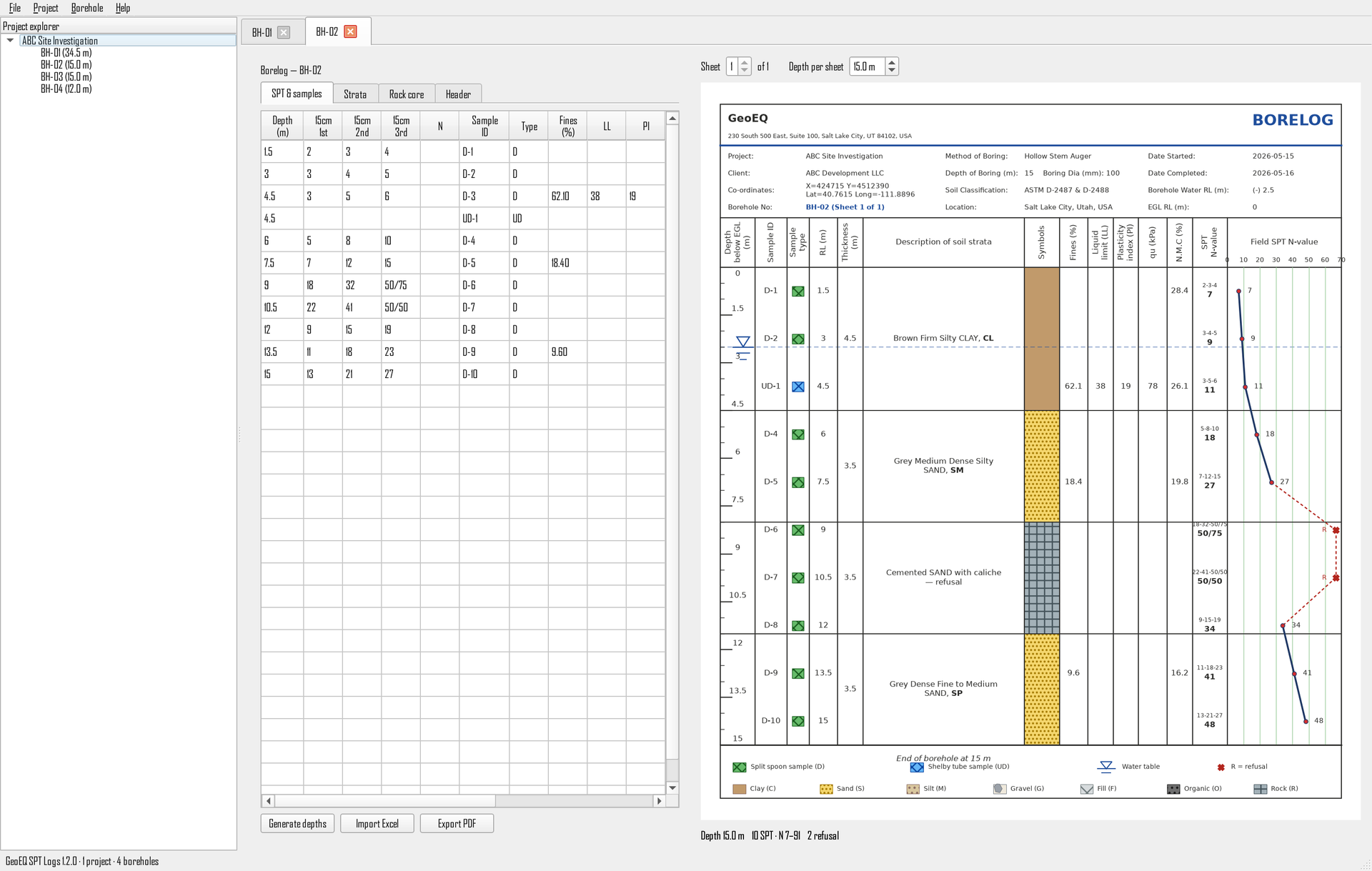
Enter 150 mm blow counts, samples, lab results and strata beside a live preview of the finished sheet. The SPT N-value curve and pagination update immediately.
GeoEQ SPT Logs · Version 1.2 · Free download
Turn SPT field sheets and Excel data into publication-ready soil boring logs — strata, sample records, groundwater and the N-value profile, drawn as you type. Unlimited boreholes, one-click PDF, no subscription and no account. A straightforward alternative when a full data platform is more than the job needs.
What it is
A boring log—also called a borehole log, bore log or borelog—records the subsurface conditions encountered during drilling. GeoEQ SPT Logs is free Windows software that turns field tables and spreadsheets into standardized, publication-ready logs without building a custom Excel template or subscribing to a large data platform.
The application stays focused on the deliverable: SPT blow counts, soil strata, sample records, laboratory values, groundwater, company identity and the N-value-versus-depth plot. Project data stays local and the program continues working when the computer is offline.
Product walkthrough
Follow the actual workflow inside GeoEQ SPT Logs. These are real product screens from version 1.2—not concept renders.
01 · Enter and review
Enter 150 mm blow counts, samples, lab results and strata beside a live preview of the finished sheet. The SPT N-value curve and pagination update immediately.
Capabilities
Eight focused capabilities cover the daily SPT logging workflow without hiding the work behind a database-heavy interface.
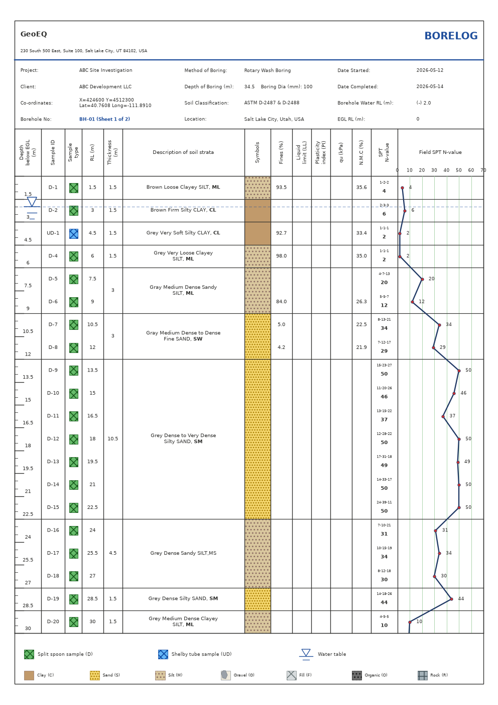
Enter depths, 150 mm blow counts, samples, strata and lab results beside the finished borehole log. The depth scale, symbols, pages and SPT N-value profile redraw immediately.
Record three penetration increments or enter a direct N-value. GeoEQ computes the second-plus-third increment, handles refusal and plots N against depth.
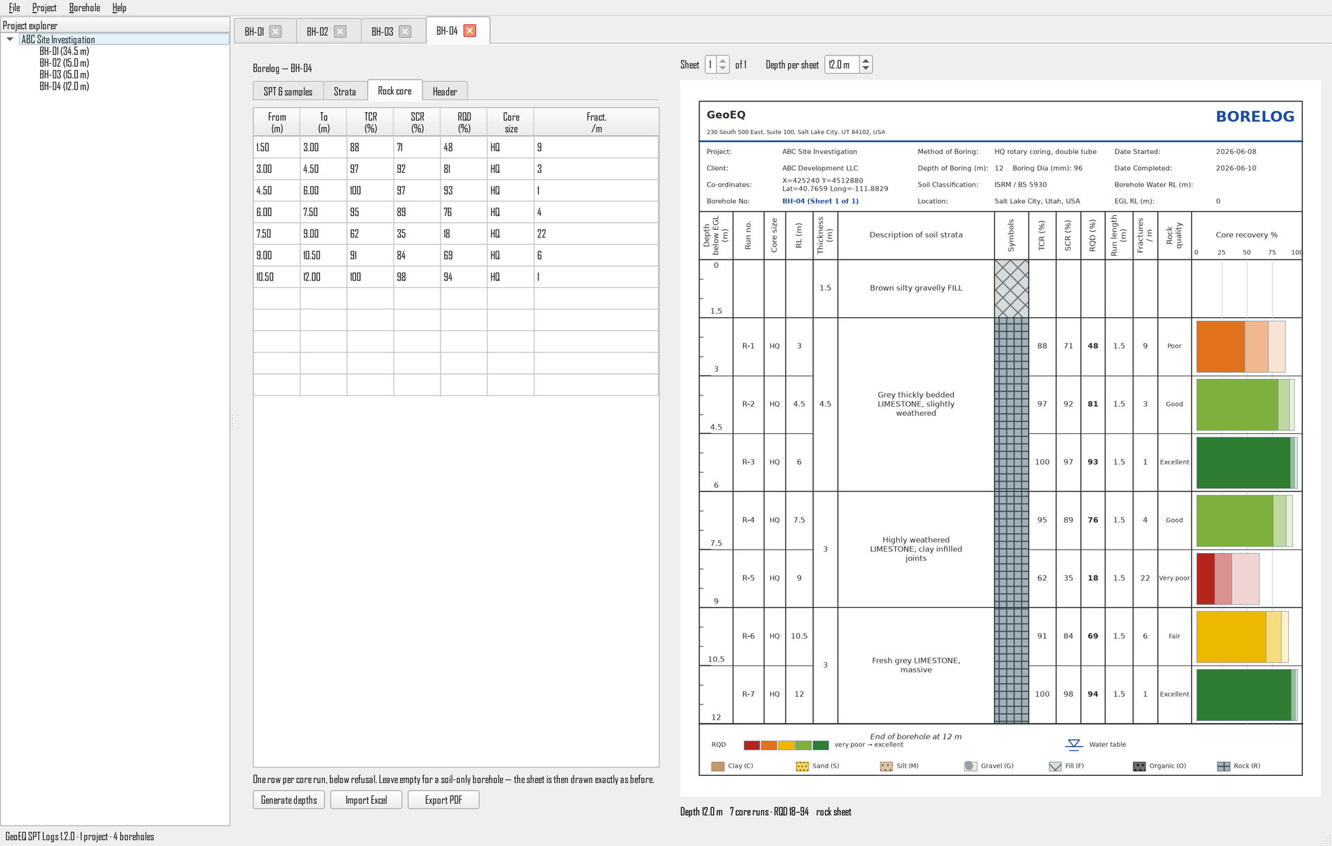
Record one row per core run: run depths, total and solid core recovery, RQD, core size and fractures per metre. Run number, run length and the RQD rock quality description are derived for you.
Enter core runs beside the SPT rows and the sheet continues past refusal by itself — N-value graph above the rockhead, core recovery below it. A borehole with no SPT data draws as a rock log. Nothing to switch on.
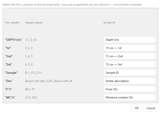
Import familiar office templates directly. For non-standard files, confirm the automatically suggested mapping for depth, blows, samples, descriptions and lab columns.
Draw Clay, Sand, Silt, Gravel, Fill, Organic and Rock with recognizable hatching, color and bold USCS group symbols such as CL, ML, SM and GW.
Show split-spoon and Shelby-tube samples, disturbed and undisturbed IDs, selectable groundwater markers and the water-table line across the log.
Export one borehole or every borehole in a project to a correctly ordered, multi-page A4 PDF ready for review, issue or project records.
Set the company name, address, logo, accent color and one of four header layouts once. The selected identity is applied consistently to every borehole sheet.
No account and no cloud dependency. Projects remain as plain files on your computer, under Documents, and can be used without an internet connection.
A ten-minute first log
The installer includes a complete demo project. Use it to understand the sheet, then import an existing spreadsheet or create your own borehole.
Add the company name, address, logo, header style and accent color once.
Create a borehole or map an existing Excel or CSV field sheet.
Check the strata, samples, computed N-values, groundwater and page breaks.
Issue one log or combine every project borehole into a single A4 PDF.
Local-first by design
GeoEQ SPT Logs does not require an account or cloud connection. Projects are plain local files, stored under Documents\GeoEQ SPT Logs\Projects, so they can be copied, backed up and used on offline project machines.
Drawn to the conventions you already sign to
A practical migration path
For teams reviewing a legacy boring-log workflow, GeoEQ SPT Logs provides the essentials in a smaller Windows application: spreadsheet import, a live borehole-log editor, SPT N-value calculation and project PDF export.
It is intentionally narrower than an enterprise geotechnical database. Use it when the immediate need is to create clear, consistent SPT boring logs while keeping project files local.
See the software in useDirect answers
Product facts are kept in visible HTML and structured data so people, search engines and AI systems receive the same answer.
GeoEQ SPT Logs is free Windows boring log and borehole log software for Standard Penetration Test data. It records or imports field data and produces A4 bore logs with soil strata, samples, groundwater and an SPT N-value profile.
They are regional names for the same core geotechnical record: the subsurface conditions encountered during drilling, including strata, samples, groundwater and test results. “Boring log” is common in the United States, while “borehole log,” “bore log” and “borelog” are widely used internationally.
Yes. GeoEQ SPT Logs version 1.x is free and full-featured for commercial, academic and personal use. It does not require an account, subscription or licence key.
Yes. Standard office spreadsheets can be imported directly, and Excel or CSV files with other headings open a column-mapping window. The software suggests assignments and lets you confirm them before data enters the project.
Yes. The application works offline and stores project data as plain local files in Documents\GeoEQ SPT Logs\Projects. No cloud account is required.
The software sums the second and third 150 mm penetration blow counts to calculate the field SPT N-value. It can also accept a direct N-value, plots N against depth and handles refusal values.
Version 1.2 supports 64-bit Windows 10 and Windows 11. It is available as a standard installer and a portable ZIP package. A macOS build is planned but is not currently released.
Yes. Enter one row per core run — run top and bottom, TCR, SCR, RQD, core size and fractures per metre — and the cored interval is drawn on the log. There is no rock or soil mode to choose: a borehole with SPT rows and core runs draws both on one continuous sheet, and a borehole with only core runs draws as a rock log.
Rock Quality Designation, proposed by Deere in 1964. For each core run it is the combined length of intact, sound core pieces 100 mm (4 inches) or longer, divided by the length of the run, expressed as a percentage. RQD classifies rock as very poor (0–25%), poor (25–50%), fair (50–75%), good (75–90%) or excellent (90–100%). GeoEQ SPT Logs colours the recovery bar by this scale, so a weathered zone is visible before a number is read.
All three are the same fraction — recovered length divided by run length — with a progressively stricter definition of what counts. TCR (total core recovery) counts everything recovered from the barrel, including rubble. SCR (solid core recovery) counts only full-diameter solid cylinders. RQD counts only sound pieces 100 mm or longer. RQD is therefore always less than or equal to SCR, which is always less than or equal to TCR. GeoEQ SPT Logs uses that rule to draw all three as one nested bar, and to report a figure that breaks the order as a transcription error.
It is a focused, free gINT alternative when the required deliverable is a boring log with strata, samples, laboratory values, an N-value curve and rock core recovery. Bentley placed gINT in Support Discontinued status in January 2026. It does not replace every database, GIS or subsurface modelling capability in a larger geotechnical data platform.
Research and reporting
If the software supports a thesis, publication or technical report, use the repository citation maintained with version 1.2.0.
Malo, R. C., & Qiu, T. (2026). GeoEQ SPT Logs (Version 1.2.0) [Computer software]. GeoEQ.
View repository and CITATION.cff →GeoEQ SPT Logs 1.2
Download the Windows installer or portable package. Open the included demo project and produce your first borehole log in minutes.
64-bit Windows 10/11 · Version 1.x free · No account