Skip to content
GeoEQ · Geotechnical software research lab · University of Utah
DIGGS Viewer app icon

DIGGS Viewer

Geotechnical data viewer · Android and iPhone

Open DIGGS and AGS4 files on your phone.

DIGGS Viewer is a mobile app for geotechnical site investigation data. It reads DIGGS XML and AGS4 files and shows boreholes, boring logs with SPT, CPT profiles, groundwater and lab tests, offline.

iPhone needs iOS 16.4 or later. Questions? Email [email protected].

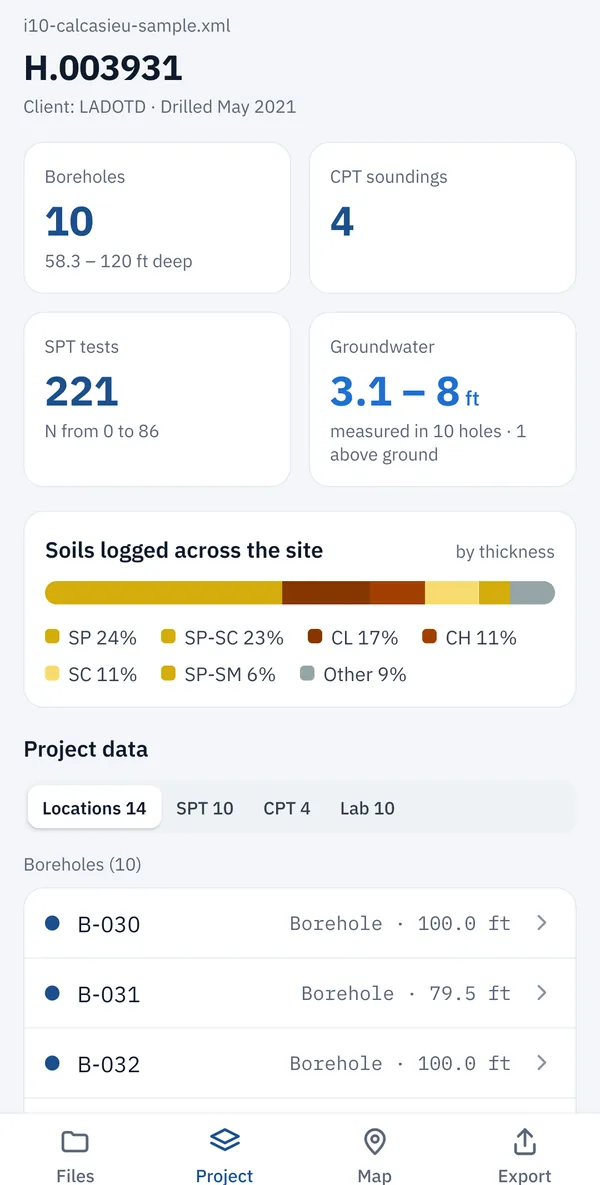
DIGGS Viewer project overview: 10 boreholes, 4 CPT soundings, 221 SPT tests and groundwater levels
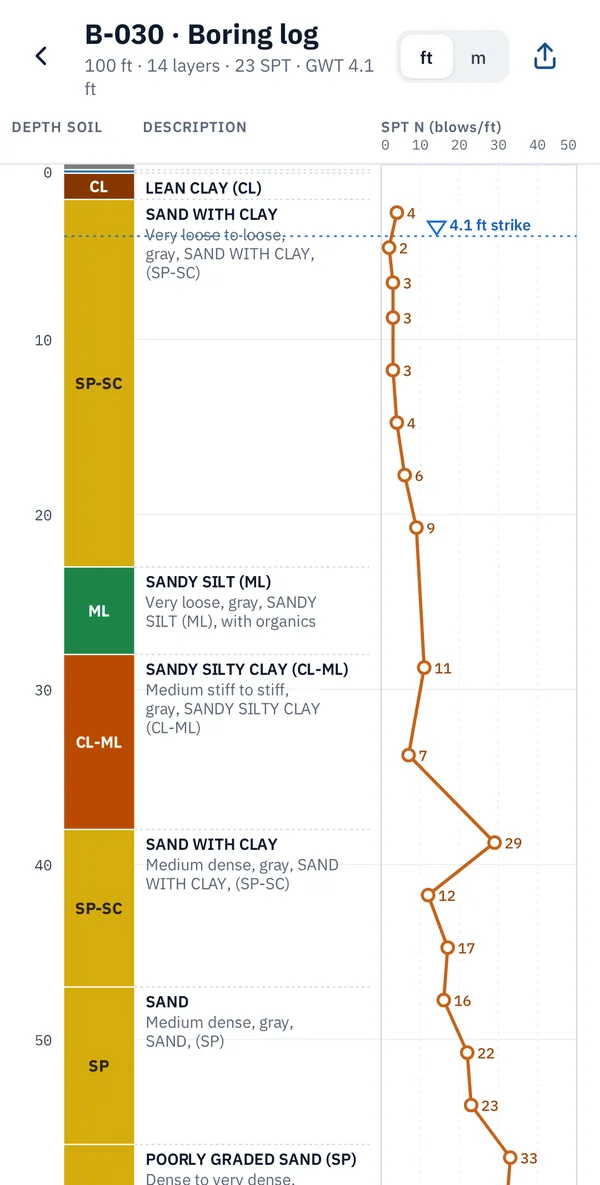
Boring log in DIGGS Viewer with soil column, descriptions, SPT N-values and water level

The file formats

What are DIGGS and AGS files?

DIGGS and AGS are the two open formats for passing ground investigation data between organisations: the boreholes, samples, in-situ tests and lab results behind a boring log, in a form any software can read. DIGGS is the standard in the United States; AGS4 is the standard in the UK and on many international projects.

DIGGS

Data Interchange for Geotechnical and Geoenvironmental Specialists

An XML standard for exchanging borehole, in-situ test and laboratory data. It was developed with FHWA and the ASCE Geo-Institute and is used by US state departments of transportation.

Structure
XML text, structured by a published schema
Where
United States, state DOTs and their consultants
Extensions
.xml, .diggs
DIGGS Viewer reads
Versions 2.5, 2.6 and 3.x

AGS4

Association of Geotechnical and Geoenvironmental Specialists

The geotechnical data transfer format of the AGS, widely used in the UK and internationally. A plain text file of data groups, such as locations, geology, samples and SPT, that gINT and other logging software can export.

Structure
Plain text, comma-separated data groups
Where
UK, Ireland and international projects
Extensions
.ags
DIGGS Viewer reads
AGS 4.0 and 4.1, with British National Grid, Irish Grid and ITM

Why a viewer

The data is open. Reading it is the hard part.

A DIGGS or AGS file can hold a whole site investigation, but it is built for one program to hand to another. DIGGS Viewer draws it the way an engineer reads it, on the phone you already carry.

  1. 01

    The files are written for software, not people

    Open a DIGGS file and you see XML tags; open an AGS file and you see rows of codes. The boring logs inside are only readable once a program draws them.

  2. 02

    The programs that read them sit on a desk

    Logging and database software runs on office computers. On site, at a review meeting or between jobs, the data is effectively locked.

  3. 03

    Checking a delivery should take minutes

    Does the file hold every borehole? Are the water levels there? Is the SPT plotted at the right depth? A viewer answers that before the file is accepted.

  4. 04

    Nearby data is scattered

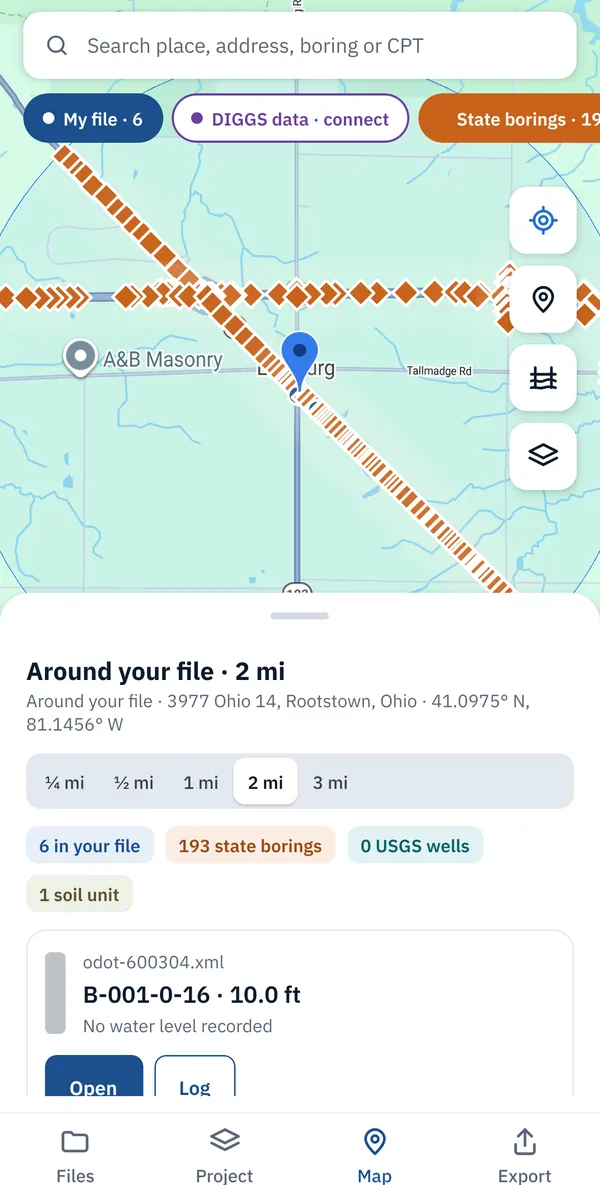
    Public wells, soil surveys and DOT borings live in separate portals. Seeing them around a site, on the same map as your file, takes one search instead of several.

At a glance

DIGGS Viewer in eight lines.

A viewer for the two main geotechnical data transfer formats, made for checking site investigation data in the field.

What it is
A mobile viewer for DIGGS and AGS geotechnical data files
File formats
DIGGS XML 2.5, 2.6 and 3.x (.xml, .diggs) · AGS4 (.ags)
Platforms
iPhone (iOS 16.4 or later) on the App Store, and Android on Google Play
Shows
Boreholes, boring logs, SPT N-values, CPT (qc, fs, Rf, u2, Ic), groundwater, lab tests, cross-sections, maps
Export
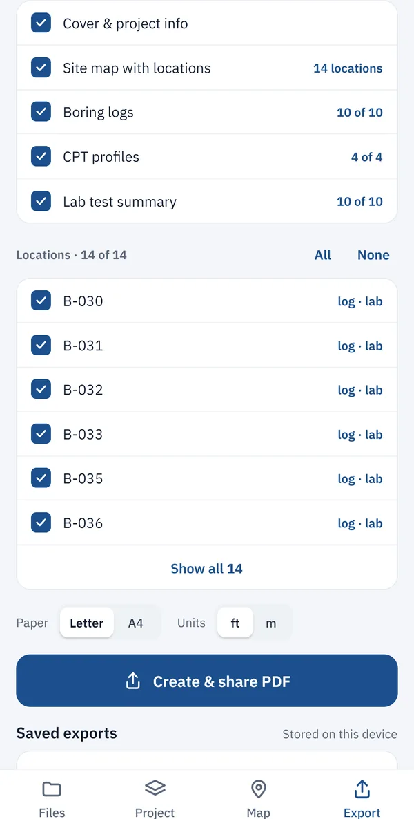
PDF report: cover, site map, boring logs, CPT profiles and lab summary
Offline
Yes. Files open and display without internet
Privacy
Files stay on your device. No account, ads or tracking
Developer
Ripon C Malo (University of Utah)

What you can do with it

The whole site investigation, laid out from one file.

Open a file from Files, email, Google Drive or AirDrop and DIGGS Viewer lays out every borehole, sounding and test in it.

Boring logs with SPT

  • Soil column by USCS group or material
  • SPT N-values with depth, including refusal
  • Water strikes and measured levels
  • Feet or metres at a tap

CPT profiles

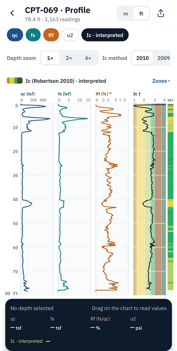
  • qc / qt, sleeve friction fs, friction ratio Rf, pore pressure u2
  • Soil behaviour type index Ic (Robertson), labelled as interpreted

Lab test charts

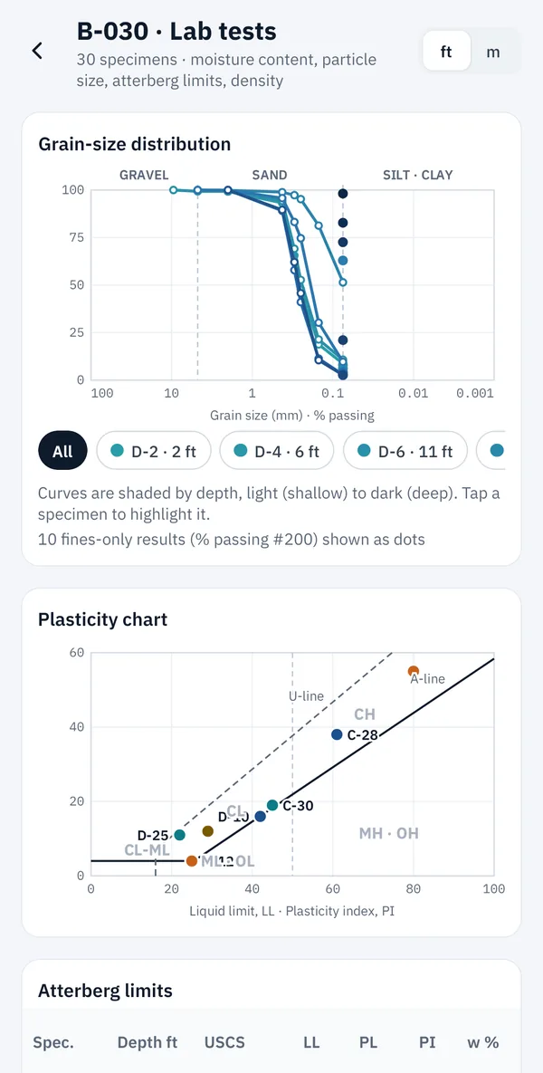
  • Grain-size distribution curves
  • Plasticity chart and Atterberg limits (LL, PL, PI)
  • Moisture, density, strength and compaction

Maps, sections and soil maps

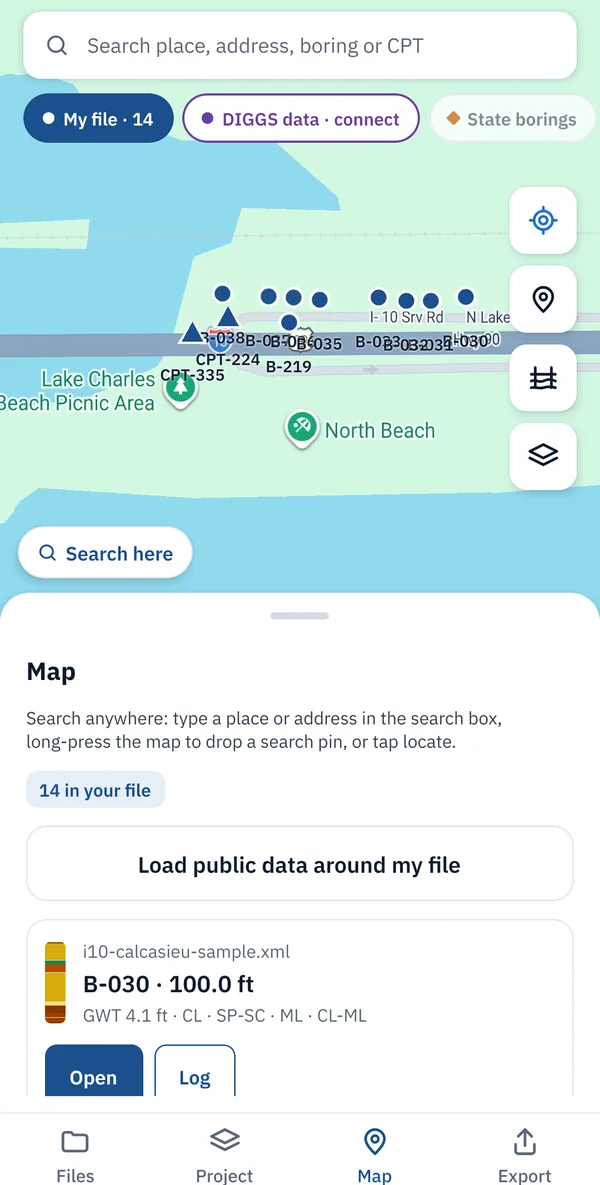
  • Every borehole and CPT on a map, converted from the file's coordinate system
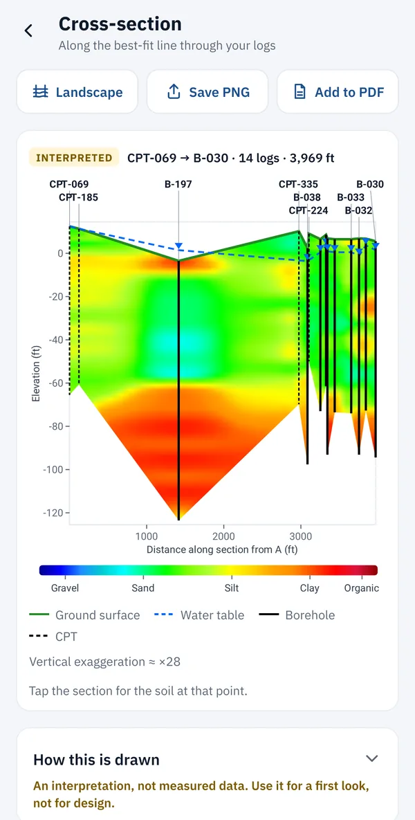
  • Cross-section through the boreholes you pick
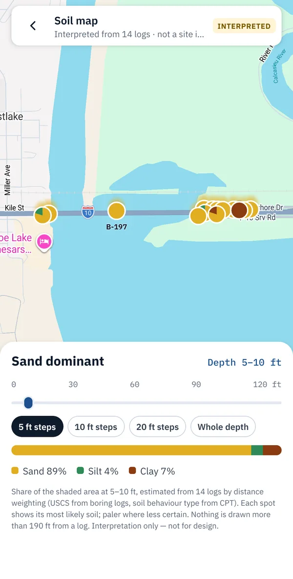
  • Most likely soil across the site at a chosen depth

Public data near a site

  • USGS groundwater wells and USDA NRCS soil survey
  • State DOT boring layers
  • DIGGS data from Geosetta with a free Geosetta account

PDF reports from the field

  • Cover, site map, boring logs, CPT profiles and lab summary
  • Letter or A4, feet or metres
  • Made on the phone, no internet needed

Screenshots

Nine screens from real DOT data.

Shown with the built-in I-10 Calcasieu River Bridge sample (LADOTD) and public Ohio DOT borings.

Project overview of a DIGGS file with borehole, CPT, SPT and groundwater counts
Project overviewEverything in the file at a glance
Boring log with soil layers, SPT N-values and groundwater level
Boring logsSoil column, SPT and water levels
CPT profile with cone resistance, sleeve friction, friction ratio and Ic
CPT profilesqc, fs, Rf, u2 and Ic
Map of boreholes and CPT soundings from a DIGGS file
MapEvery location in its real place
Interpreted cross-section between selected boreholes
Cross-sectionsPick boreholes, get a soil profile
Grain-size curves and plasticity chart from lab test data
Lab testsGrain size, plasticity, Atterberg limits
Soil map showing the most likely soil across the site at 5 to 10 feet depth
Soil mapLikely soil at a chosen depth
Nearby public data: state DOT borings, USGS wells and soils around a file
Nearby public dataDOT borings, wells, soils, Geosetta
Export screen for a PDF report with boring logs, CPT and lab summary
PDF reportsMade offline on the phone

Measured or interpreted

A viewer that never changes your data.

Values are shown as recorded in the file. Anything the app works out, such as the CPT soil behaviour type index Ic, a cross-section between boreholes or a soil map at a depth, is labelled as interpreted. Use those for a first look, not for design.

Who it is for

  • Geotechnical engineers
  • Engineering geologists
  • Drillers and loggers
  • State DOT staff
  • Consultants and reviewers
  • Students and researchers

Your files stay on your device. The app has no accounts of its own, no ads, analytics or tracking. Read the privacy policy.

Questions

Common questions.

More help on the support page.

What is a DIGGS file?

DIGGS (Data Interchange for Geotechnical and Geoenvironmental Specialists) is an XML standard for exchanging borehole, in-situ test and laboratory data. It was developed with FHWA and the ASCE Geo-Institute and is used by US state departments of transportation.

What is an AGS file?

AGS4 is the geotechnical data transfer format of the Association of Geotechnical and Geoenvironmental Specialists, widely used in the UK and internationally. gINT and other logging software can export it.

What app opens DIGGS files on a phone?

DIGGS Viewer opens DIGGS XML files (versions 2.5, 2.6 and 3.x) on Android and iPhone and shows the boreholes, boring logs, SPT, CPT, groundwater and lab tests, offline.

Can I open AGS4 files on my phone?

Yes. DIGGS Viewer opens AGS4 (.ags) files, including British National Grid, Irish Grid and ITM coordinates. AGS 3 files must be re-saved as AGS4 first.

Does DIGGS Viewer need the internet?

No. Files open and display offline. The internet is only used for the map background and, if you choose, for searching public data near a site.

Does DIGGS Viewer upload my files?

No. Files are read and stored only on your device. The app has no accounts of its own, no ads and no analytics or tracking.

Does DIGGS Viewer change my data?

No. It is a viewer. Values are shown as recorded in the file, and anything interpreted, such as CPT Ic or a cross-section between boreholes, is labelled as interpreted.

How do I see Geosetta data?

Sign in with a free Geosetta account under Settings in the app. Geosetta DIGGS data then appears on the map and in the nearby search. Data from Geosetta (geosetta.org).

Is DIGGS Viewer available on iPhone and Android?

Yes. DIGGS Viewer is on the App Store for iPhone (iOS 16.4 or later) and on Google Play for Android.

iPhone and Android

Get DIGGS Viewer on your phone.

On the App Store for iPhone (iOS 16.4 or later) and on Google Play for Android. A file that does not open as expected? Write to us.

DIGGS Viewer is developed by Ripon C Malo (University of Utah).

Data from Geosetta (geosetta.org) is shown for users who sign in with their own Geosetta account; DIGGS Viewer is not affiliated with or endorsed by Geosetta. DIGGS is a standard of the DIGGS project; AGS is a format of the Association of Geotechnical and Geoenvironmental Specialists.

Google Play is a trademark of Google. App Store is a service mark of Apple.