GeoEQ Learn
Learn GeoEQ software, one program at a time.
User guides, step-by-step tutorials, engineering notes and a glossary for geotechnical site investigation software. Every page starts with the answer.
User guides
Available · v1.2 GeoEQ SPT Logs user guide Boring logs from SPT, strata and rock core: setup, data entry, import, export and Connect AI. Documentation · 15 Tutorials · 10 What's new Open source geoeq for Python Scripted geotechnical calculations. Tutorials here, the full API reference at docs.geoeq.org. Tutorials · 2 API docs ↗
Guides at release DEM · Cap · Liq · Lab · Seismic Each program gets its own user guide the day it is released. See the software →
-
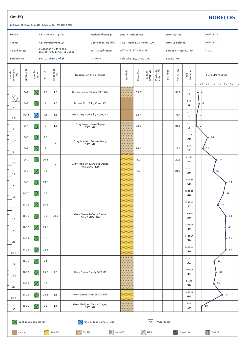 Tutorial · Manual15 min How to make a boring log (borehole log) in GeoEQ SPT Logs To make a boring log, add a project and a borehole in GeoEQ SPT Logs, enter the SPT blows, strata and header facts, and check the sheet that redraws beside the tables. N is computed from the 2nd and 3rd 15 cm blow counts. SPT LogsBeginner
-
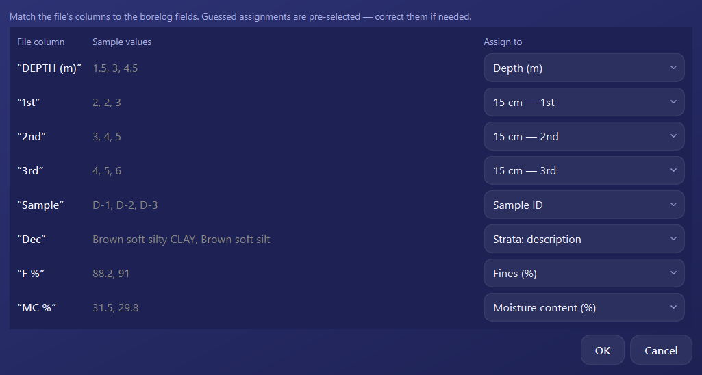 Tutorial · Manual10 min Import boring log data from Excel or CSV into GeoEQ SPT Logs In GeoEQ SPT Logs, right-click the project and choose Import borehole, pick your Excel or CSV file, and confirm the guessed column mapping in the Assign columns window. The rows are then inserted into a new borehole and the log sheet is drawn. SPT LogsBeginner
-
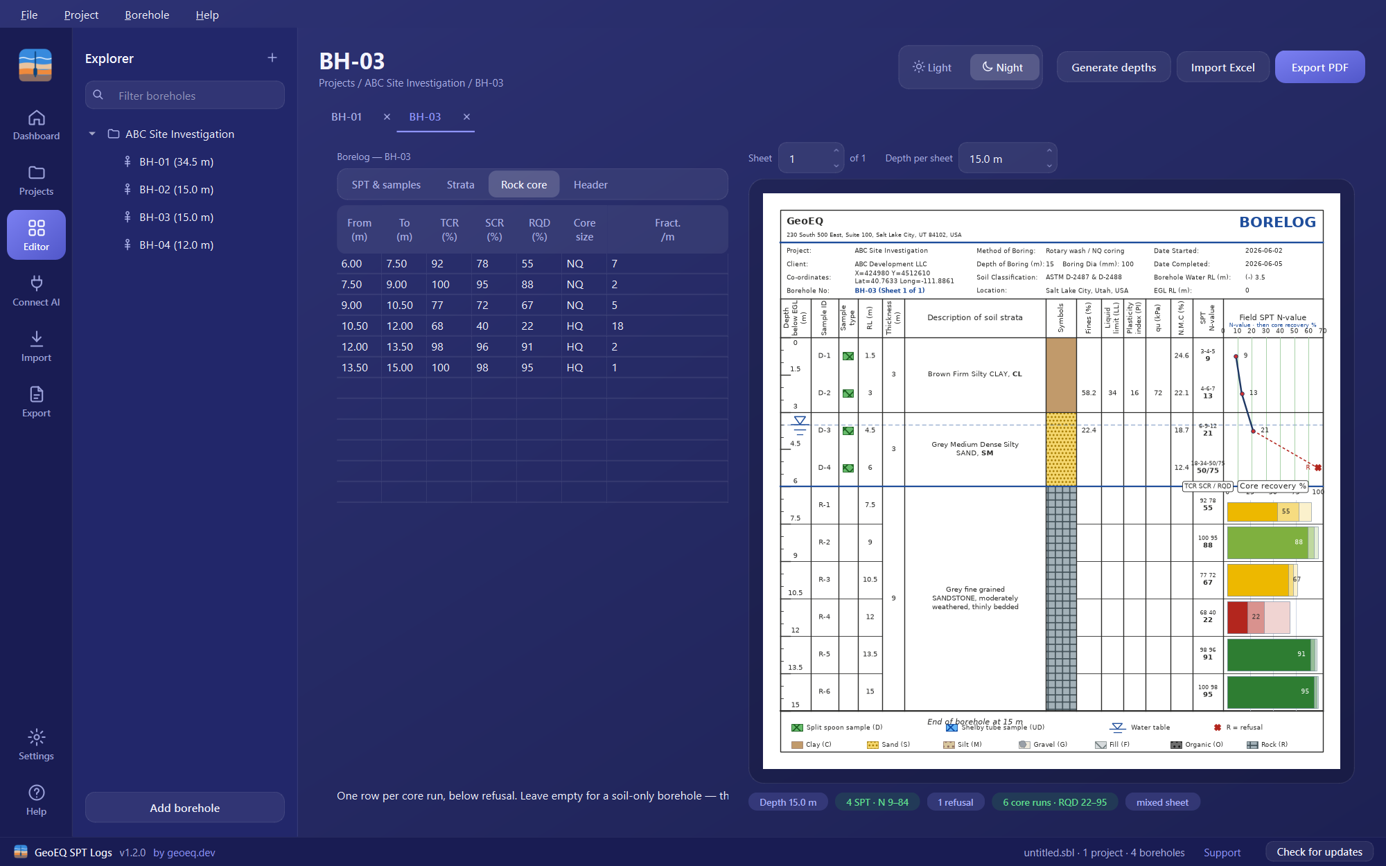 Tutorial · Manual15 min How to log rock core: run, recovery and RQD in GeoEQ SPT Logs RQD is the sum of intact core pieces 100 mm or longer divided by the core run length, times 100 (ASTM D6032). In GeoEQ SPT Logs, enter each run's top, bottom, TCR, SCR and RQD in the Rock core tab and the sheet draws one colour-coded recovery bar per run. SPT LogsIntermediate
- Tutorial · Manual8 min Borelog template: company header, logo and accent colour In GeoEQ SPT Logs, choose File, then Company settings, and enter your company name, address and logo, then pick a header style and accent colour. These settings are drawn on every sheet of every project, so the borelog template is set up once. SPT LogsBeginner
- Tutorial · Manual5 min Export boring logs to PDF: one file for the whole site In GeoEQ SPT Logs, right-click the project and choose Export project PDF to get every borehole's sheets, in order, in a single PDF. For one borehole, use the Export PDF button in its borelog tab. What you see on screen is what is exported. SPT LogsBeginner
- Tutorial · Python Tutorial · Python15 min SPT N60 Correction in Python with geoeq To correct an SPT blow count in Python, call spt_n60 from the open-source geoeq library with the field N and the hammer, borehole, sampler and rod factors, then pass the result to spt_n160 with the effective vertical stress. A field N of 18 becomes N60 = 19.75 and N1(60) = 22.08. geoeq for PythonIntermediate
- inputs = dict(c=25, gamma=18, Df=1.5, B=2, phi=30) Tutorial · Python15 min Bearing Capacity Calculation in Python with geoeq To calculate shallow-foundation bearing capacity in Python, call bearing_capacity from the open-source geoeq library with c, gamma, Df, B and phi. For a 2 m strip footing at 1.5 m depth on c = 25 kPa, phi = 30 degrees soil, the Meyerhof method gives q_u = 1829.29 kPa. geoeq for PythonIntermediate
-
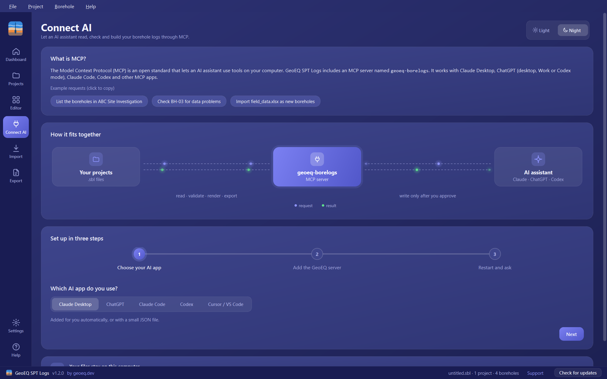
 Tutorial · With AI15 min Connect Claude or ChatGPT to your boring logs with MCP Open Connect AI in GeoEQ SPT Logs, choose your AI app, copy the geoeq-borelogs server entry into that app's config, then restart the app and ask about your project. The assistant can then read, check, draw and export boreholes from your .sbl files, and it can change them only if you allow writing and approve each change. SPT LogsIntermediate Requires v1.3
-
 Tutorial · With AI15 min Import hundreds of boreholes from Excel with an AI assistant Ask your connected AI assistant to inspect the spreadsheet, agree the column mapping with you, run the import as a dry run and apply it only when the preview is right. It needs GeoEQ SPT Logs 1.3 or later with Connect AI set up, and writing switched on. SPT LogsIntermediate Requires v1.3
- Tutorial · With AI15 min Turn a field sheet into a boring log with an AI assistant Give your connected AI assistant the field sheet, ask it to draft the borehole, review the dry run and apply it, then render the sheet and compare it with the original. It needs GeoEQ SPT Logs 1.3 or later with Connect AI set up, and writing switched on. SPT LogsIntermediate Requires v1.3
- Tutorial · With AI15 min Check every boring log for data errors with an AI assistant Ask your connected AI assistant to validate the whole project, group the issues by code, then propose single-cell corrections as a dry run for you to approve. It needs GeoEQ SPT Logs 1.3 or later with Connect AI set up, and writing switched on for the corrections. SPT LogsIntermediate Requires v1.3
- Tutorial · With AI10 min Export boring logs to PDF with an AI assistant Ask your connected AI assistant to draw a sheet to check it, then export the project to a folder as one PDF per borehole or a single combined PDF. It needs GeoEQ SPT Logs 1.3 or later with Connect AI set up; exporting works with writing switched off. SPT LogsIntermediate Requires v1.3
- Windows 10 / 11 Guide · Getting started Install GeoEQ SPT Logs on Windows (free download) GeoEQ SPT Logs is free Windows software for 64-bit Windows 10 and 11. Download it from geoeq.dev/download after creating a free account, run the installer (no administrator rights needed), then open File, Open demo project to see a finished log. SPT Logsv1.0+
- file, project, borehole Guide · Getting started Files, projects and boreholes in GeoEQ SPT Logs (.sbl) A GeoEQ SPT Logs project file (.sbl) holds one or more projects, and each project holds boreholes. Every borehole has one borelog, with its SPT data, strata and header, and draws its sheet live. Right-click any item in the explorer for its actions. SPT Logsv1.0+
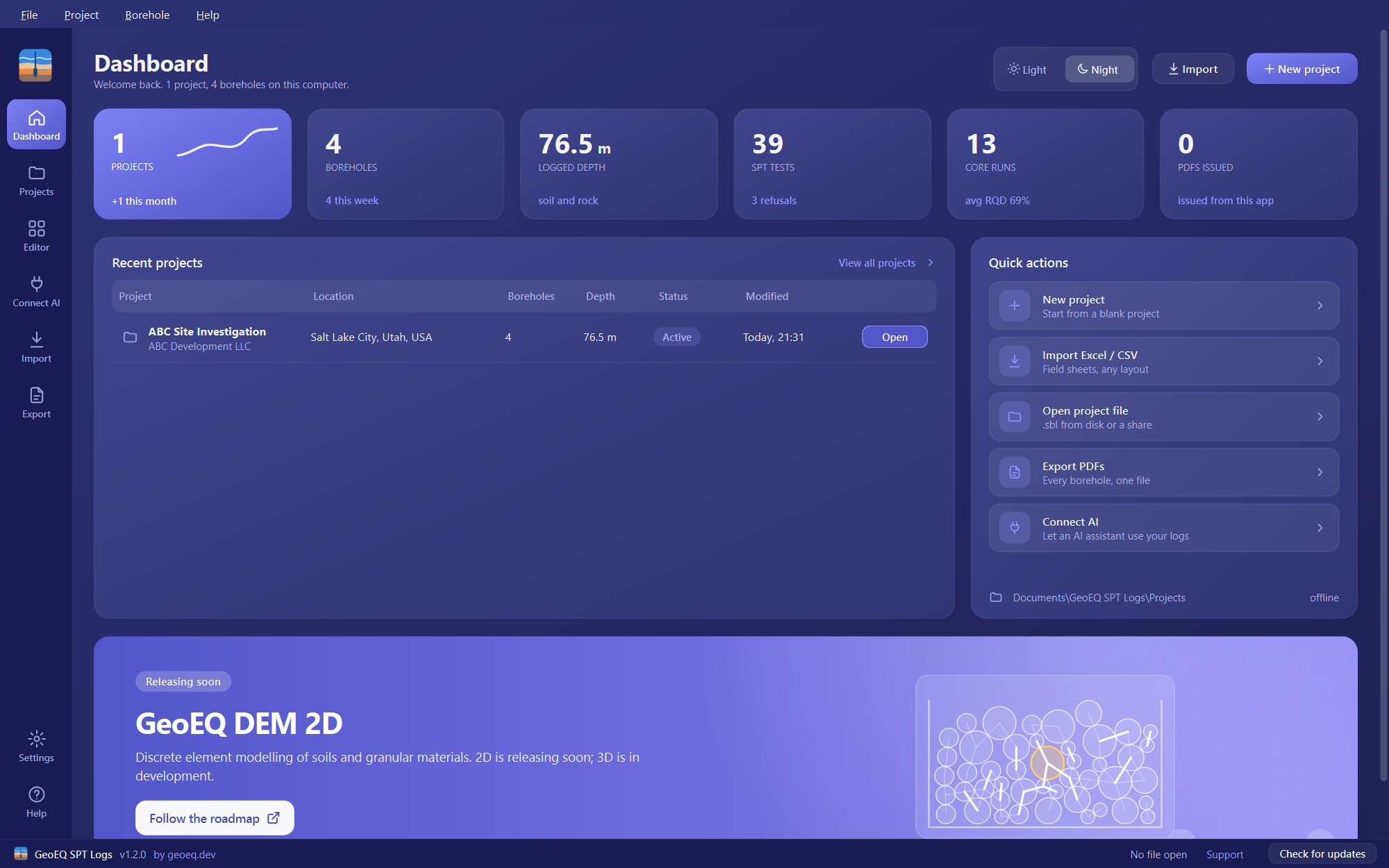
- 6 totals Guide · Getting started Dashboard, Projects page and Night theme in GeoEQ SPT Logs 1.3 From version 1.3, GeoEQ SPT Logs opens on a Dashboard that totals your projects, boreholes, depth, SPT tests, core runs and exported PDFs. A Projects page lists every project on the computer, with status filters, batch actions and a strata preview, and a Light or Night theme switch sits at the top of each page. SPT Logs Requires v1.3
- 4 header styles Guide · Getting started Company settings: letterhead, logo and sheet title in SPT Logs Open File, Company settings once and set your company name, address, logo, header style, accent colour, sheet title and water row label. They are drawn on every sheet of every project, so each log you issue carries the same letterhead and wording. SPT Logsv1.0+
- 1.5 m / 1.5 m Guide · Getting started Project settings in GeoEQ SPT Logs: units, N-graph and refusal Double-click a project (or right-click, Project settings) to set units, test interval, N-value graph scale, how values past the scale are drawn, how refusal reads in the N column, coordinate display and water marker. Units change labels only; values are never converted. SPT Logsv1.1+
- N = 2nd + 3rd Guide · Logging SPT blow counts, N-value and samples in GeoEQ SPT Logs On the SPT & samples tab, enter one row per test: depth, the three 15 cm blow counts, sample ID, type (D or UD) and lab results. N is computed as the 2nd plus 3rd blow count, as in ASTM D1586. Type a refusal such as 50/75 straight into an increment cell. SPT Logsv1.0+
- 7 families Guide · Logging Strata, soil type letters and symbols in GeoEQ SPT Logs On the Strata tab, give each layer's bottom depth, a description and a soil type letter: C clay, S sand, M silt, G gravel, F fill, O organic or R rock. The letter is guessed from the description and sets the coloured symbol. A USCS symbol ending the description is printed in bold. SPT Logsv1.0+
- RQD ≤ SCR ≤ TCR Guide · Logging Rock core, TCR, SCR and RQD logging in GeoEQ SPT Logs Enter one row per core run on the Rock core tab: top, bottom, TCR, SCR, RQD, core size and fractures per metre. The sheet follows the data with no setting to change, and each run is drawn as one recovery bar coloured by Deere's rock quality band. SPT Logsv1.2+
- Guide · Logging Borehole header and groundwater level in GeoEQ SPT Logs The Header tab holds the facts that belong to one borehole: X/Y and Lat/Long coordinates, dates, method of boring, boring diameter, soil classification, EGL reduced level and Water RL. The number in the Water RL field, for example (-) 5.0, places the water table marker 5.0 m below the ground surface on the sheet. SPT Logsv1.0+
- Guide · Data in and out Import boring log data from Excel or CSV in GeoEQ SPT Logs Right-click a project in GeoEQ SPT Logs and choose Import borehole, then pick an .xls, .xlsx or .csv file. The office BH-xx template imports in one click. Any other table opens the Assign columns window, where you correct the guessed mapping and press OK. SPT Logsv1.0+
- Guide · Data in and out Export boring logs to PDF: one borehole or a whole project To export one borehole, press Export PDF in its borelog tab, or right-click it and choose Export PDF. To export a whole project, right-click the project and choose Export project PDF, which writes every borehole's sheets, in order, into a single PDF. The PDF is the same drawing you see on screen. SPT Logsv1.0+
- Guide · Data in and out Connect AI in GeoEQ SPT Logs: use MCP with your boring logs Connect AI adds a local MCP server named geoeq-borelogs to your own AI app, such as Claude Desktop, ChatGPT, Claude Code, Codex, Cursor or VS Code. It is read-only by default, offers seven tools, and your project files stay on your computer. It needs GeoEQ SPT Logs version 1.3 or later. SPT Logs Requires v1.3
- 12 / 3 / 7 Guide · Reference The .sbl project file format: JSON structure and row layout A GeoEQ SPT Logs project file (.sbl) is plain UTF-8 JSON: a top-level object with a version and a list of projects, each holding boreholes, and each borehole holding a header, spt rows (12 cells), strata rows (3 cells) and optional core rows (7 cells). You can read it directly with any JSON library. SPT Logsv1.0+
- Help Guide · Reference Update GeoEQ SPT Logs and find where your data is stored Choose Help, then Check for updates, to compare your version with the latest release and get a download link when a newer one exists. Your projects are stored in Documents\GeoEQ SPT Logs\Projects and your settings in %APPDATA%\GeoEQ\SPT Logs, never in the installation folder, so updating or uninstalling does not touch them. SPT Logsv1.0+
- 50/75 Guide · Reference GeoEQ SPT Logs tips and FAQ: refusal, water marker, N scale Most questions come down to a few settings: the water marker follows the number in the Water RL header field, refusal is typed as 50/75 in the increment cell, and values past the N-value scale are capped at 50 by default until you change Values past the scale in Project settings. SPT Logsv1.0+
- Field practice Engineering note SPT N-value corrections: N60 and N1(60) explained What each SPT correction factor does, when it applies, and a worked example taking a field blow count of 18 through energy, borehole, rod, sampler and overburden corrections to N1(60). Field practice
- Laboratory Engineering note Reading the plasticity chart: how USCS symbols are decided How Atterberg limits become a USCS group symbol — the A-line, the U-line, the CL-ML band, and the checks that catch a misclassified sample before it reaches the borehole log. Laboratory
- Glossary · Site investigation Boring log A record of the soil and rock encountered in a borehole during drilling, including strata, samples, groundwater and in-situ test results. “Boring log” is the usual term in the United States and “borehole log” in the UK, Europe and Australia; no formal distinction between them was found.
- Glossary · Site investigation Standard Penetration Test (SPT) An in-situ test in which a 63.5 kg hammer falling 760 mm drives a split-barrel sampler 450 mm in three 150 mm increments (ASTM D1586). The N-value is the number of blows for the second and third increments; the first is a seating drive. Refusal is reported with the penetration reached, for example 50/125 mm.
- Glossary · Site investigation Hammer energy ratio The energy actually delivered to the SPT drill rods divided by the theoretical energy of the hammer drop, about 475 J, expressed as a percentage and measured as described in ASTM D4633. The energy correction is CE = ER / 60, so a rig with a measured ER of 55% has CE of about 0.92.
- Glossary · Site investigation N60 The SPT blow count corrected to 60% hammer energy: N60 = N × CE × CB × CR × CS, where the factors account for hammer energy, borehole diameter, rod length and sampler type. It removes equipment effects so blow counts from different rigs can be compared.
- Glossary · Site investigation Overburden correction (CN) A factor that normalises an SPT result to a reference effective vertical stress of one atmosphere (about 100 kPa) so tests at different depths can be compared. A common form is CN = (Pa / σ′v)^0.5, capped at 1.7; it applies to granular soils, not clays.
- Glossary · Site investigation N1(60) N60 further corrected for effective overburden stress: N1(60) = N60 × CN. It is the value used for relative density estimates in sands and as the input to SPT-based liquefaction triggering procedures.
- Glossary · Site investigation Cone Penetration Test (CPT) An in-situ test in which an instrumented cone is pushed into the ground at a constant rate, about 20 mm/s, recording tip resistance, sleeve friction and, for CPTu, pore pressure (ASTM D5778). It gives a near-continuous profile and is widely used for stratigraphy and liquefaction assessment.
- Glossary · Site investigation Rock Quality Designation (RQD) The combined length of sound core pieces 100 mm (4 in) or longer, divided by the length of the core run, expressed as a percentage (Deere, 1964; ASTM D6032). It is a simple index of fracturing and is reported alongside core recovery.
- Glossary · Site investigation Total core recovery (TCR) The length of core recovered from a run, including broken pieces, divided by the run length, as a percentage. For the same run it is never smaller than the solid core recovery or the RQD.
- Glossary · Site investigation Solid core recovery (SCR) The length of full-diameter solid core cylinders recovered from a run, divided by the run length, as a percentage. Unlike RQD it does not require a minimum piece length.
- Glossary · Laboratory Grain size distribution The percentage of a soil, by dry mass, finer than each particle size, plotted as a grading curve against a logarithmic size axis. The sieve part is run to ASTM D6913 and the sedimentation part to ASTM D7928.
- Glossary · Laboratory Hydrometer analysis A sedimentation test that finds the particle size distribution of the material finer than the 0.075 mm (No. 200) sieve from the changing density of a soil suspension (ASTM D7928).
- Glossary · Laboratory Coefficient of uniformity and curvature (Cu, Cc) Cu = D60 / D10 and Cc = D30² / (D10 × D60), where Dn is the diameter at which n percent of the sample by dry mass is finer. In ASTM D2487 a well-graded gravel needs Cu of at least 4 and a well-graded sand Cu of at least 6, each with Cc from 1 to 3.
- Glossary · Laboratory Atterberg limits The water contents at which a fine-grained soil changes between liquid, plastic and semisolid behaviour, chiefly the liquid limit and the plastic limit, measured on the fraction passing the 0.425 mm (No. 40) sieve (ASTM D4318).
- Glossary · Laboratory Liquid limit (LL) The water content, in percent, at which a soil passes from plastic to liquid behaviour, read from the flow curve at 25 blows and reported as a whole number (ASTM D4318; AASHTO T 89).
- Glossary · Laboratory Plastic limit (PL) The water content, in percent, at which a soil passes from semisolid to plastic behaviour, found by rolling threads of soil to 3.2 mm diameter until they crumble (ASTM D4318).
- Glossary · Laboratory Plasticity index (PI) Liquid limit minus plastic limit, in percentage points: PI = LL − PL. It is the range of water content over which the soil is plastic, and the vertical axis of the plasticity chart.
- Glossary · Laboratory A-line and U-line On the plasticity chart the A-line, PI = 0.73 (LL − 20), separates clays (above) from silts and organic soils (below). The U-line, PI = 0.9 (LL − 8), is an empirical upper bound, and a result plotting above it usually points to a testing or reporting error (ASTM D2487).
- Glossary · Laboratory Unified Soil Classification System (USCS) A soil classification system in ASTM D2487 that assigns a group symbol such as SW, SM, CL or CH from grain size distribution and Atterberg limits. A soil is fine-grained when more than 50% passes the 0.075 mm sieve; dual symbols such as CL-ML are used where the data do not support a single group.
- Glossary · Laboratory AASHTO soil classification A highway-oriented classification (AASHTO M 145) that places a soil in groups A-1 to A-7 using the percentage passing the 0.075 mm sieve, liquid limit and plasticity index. Soils with 35% or less passing are granular; those with more than 35% are silt-clay materials. A group index may be added.
- Glossary · Foundations Ultimate bearing capacity The contact pressure at which the soil beneath a foundation fails in shear. In the general form, a cohesion term c·Nc, a surcharge term q·Nq and a self-weight term 0.5·γ·B·Nγ are added, each with shape, depth and inclination factors.
- Glossary · Foundations Bearing capacity factors (Nc, Nq, Nγ) Dimensionless factors that depend only on the soil friction angle φ. Nq = e^(π tan φ) tan²(45° + φ/2) and Nc = (Nq − 1) cot φ are common to the standard methods, while Nγ is defined differently by Meyerhof, Hansen and Vesic, so results differ between methods.
- Glossary · Foundations Depth factors (dc, dq, dγ) Multipliers in the bearing capacity equation that account for the shear strength of the soil above the foundation base, increasing capacity with embedment depth Df relative to width B. Their form depends on the method (Meyerhof, Hansen, Vesic).
- Glossary · Foundations Allowable bearing capacity and factor of safety The ultimate bearing capacity divided by a factor of safety, q_a = q_u / FS, with FS commonly taken as 3 for static loads unless the governing code sets another value. The allowable value may also be limited by the settlement the structure can tolerate.
- Glossary · Liquefaction & seismic Soil liquefaction The loss of strength and stiffness of saturated, loose, mostly cohesionless soil when cyclic loading from an earthquake raises pore water pressure toward the effective overburden stress. Triggering is usually screened with SPT or CPT based procedures such as Youd and Idriss (2001) or Boulanger and Idriss (2014).
- Glossary · Liquefaction & seismic Cyclic stress ratio (CSR) The seismic shear stress demand on a soil layer as a fraction of the effective vertical stress. The simplified form is CSR = 0.65 (amax / g) (σv / σ′v) rd, where rd is a depth-dependent stress reduction coefficient.
- Glossary · Liquefaction & seismic Cyclic resistance ratio (CRR) The cyclic stress ratio a soil layer can resist before liquefying, obtained from corrected SPT or CPT resistance and normalised to a magnitude 7.5 earthquake. A magnitude scaling factor adjusts it for other magnitudes.
- Glossary · Liquefaction & seismic Factor of safety against liquefaction The ratio of cyclic resistance to cyclic stress, FS = CRR / CSR, with magnitude scaling applied where the procedure requires it. Values below 1.0 indicate that liquefaction is predicted for that layer.
- Glossary · Liquefaction & seismic Fines content correction An adjustment that converts N1(60) to an equivalent clean-sand value, N1(60)cs, using the percentage of fines passing the 0.075 mm sieve, because silty sands show higher resistance for the same blow count. It is applied inside liquefaction triggering procedures, not to N60 or N1(60) themselves.
- Glossary · Liquefaction & seismic Vs30 The time-averaged shear-wave velocity of the upper 30 m of a profile, equal to 30 m divided by the total shear-wave travel time through those 30 m. It is the main parameter for site classification in building codes.
- Glossary · Liquefaction & seismic Site class A code category, A to F in ASCE 7 (ASCE 7-22 adds the intermediate classes BC, CD and DE), describing the stiffness of the upper 30 m of the profile, based on Vs30 or, where that is not measured, on N60 or undrained shear strength. It sets site coefficients for design ground motion, and Site Class F requires a site-specific response analysis.
- Glossary · Liquefaction & seismic Site response analysis A calculation of how the soil and rock layers beneath a site modify earthquake ground motion between bedrock and the ground surface. One-dimensional methods are linear, equivalent-linear or nonlinear; equivalent-linear analysis repeats a frequency-domain calculation with modulus and damping updated to be compatible with the computed shear strain.
- Glossary · Granular modelling Discrete element method (DEM) A numerical method that models a granular material as a collection of individual particles, calculating contact forces between them and integrating the equations of motion in time (Cundall and Strack, 1979). It is used to study soil behaviour at the particle scale.
- Glossary · Granular modelling Coordination number The average number of contacts per particle in an assembly, 2Nc / Np for Nc contacts among Np particles. It is a basic measure of packing and of how well an assembly can carry load.
- Glossary · Granular modelling Contact model The rule that converts the overlap and relative motion of two particles into normal and tangential contact forces in a discrete element simulation, such as a linear spring-dashpot or a Hertz-Mindlin model, with a friction limit on the tangential force.
Get started
Start with the one that is already free.
GeoEQ SPT Logs runs on Windows from a signed installer. A free account is needed to download; the software itself runs offline with no sign-in, no licence key and no expiry.