Documentation / Logging
Borehole header and groundwater level in GeoEQ SPT Logs
Short answer
The Header tab holds the facts that belong to one borehole: X/Y and Lat/Long coordinates, dates, method of boring, boring diameter, soil classification, EGL reduced level and Water RL. The number in the Water RL field, for example (-) 5.0, places the water table marker 5.0 m below the ground surface on the sheet.
- 10
- header fields per borehole, plus EGL RL
- 5
- water table marker styles
- ASTM D-2487 & D-2488
- default soil classification text
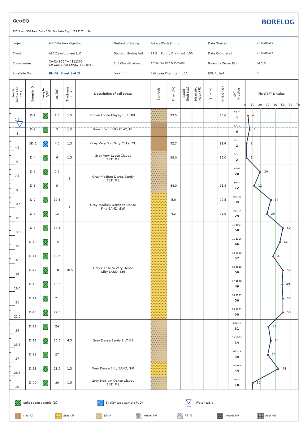
What goes on the Header tab?
Open a borehole by double-clicking it, then choose the Header tab, the fourth of the four input tabs. It holds the facts that belong to this one borehole:
| Field | What to enter |
|---|---|
| Coordinate X, Coordinate Y | Easting and northing |
| Latitude, Longitude | Geographic coordinates |
| Date started, Date completed | Drilling dates |
| Method of boring | For example Hollow Stem Auger. New boreholes start with Wash Boring |
| Water RL | The water level, for example (-) 5.0 |
| Boring dia | Hole diameter. New boreholes start at 100, in mm for a metric project |
| Soil classification | The standard the descriptions follow. New boreholes start with ASTM D-2487 & D-2488 |
| EGL RL | Reduced level of the existing ground surface, entered with a numeric spinner |
The labels for Water RL and Boring dia follow the project’s units and the water row label chosen in Company settings, so a project set to Imperial shows feet and inches. Units change labels only, and values are never converted.
Where do the project name, client and company come from?
Not from this tab. The project name, client and location are entered once in Project settings and pulled into every borelog header in that project. The company name, address and logo come from Company settings. Keeping them out of the Header tab means a change is made once and appears on every sheet.
How do coordinates work?
Each borehole stores both an X/Y pair and a Lat/Long pair. The project’s Coordinate display setting decides what the sheet prints: X/Y, Lat/Long, or both. You can fill in one pair now and add the other later.
How do I set the groundwater level?
Type the level into Water RL. The sheet reads the number in that field, so (-) 5.0 places the water table marker at 5.0 m, and the same value is printed on the sheet’s water row. The marker is drawn only when that depth falls on the sheet being shown, so on a multi-sheet log it appears on the sheet that contains it.
If the Water RL field has no number, the sheet falls back to the groundwater depth stored with the borehole. The field is the visible source of truth, so check it first when a marker looks wrong.
What does the water table marker look like?
The marker style is a project choice, set in Project settings under Water table marker:
- Classic symbol and level line (the default): the groundwater symbol plus a dashed line across the sheet at the water depth.
- Classic symbol only.
- Filled triangle.
- Triangle with a GWT label.
- Droplet.
What are EGL RL and the RL column?
EGL is the existing ground level. The sheet’s depth column is measured below it, and the RL column on the sheet is calculated from the EGL RL you enter. Leave it at 0 if you log in depths only.
Common problems
The marker did not move. Check the number in Water RL. Edit it, and the sheet redraws.
The marker is missing. The water depth is below the sheet shown. Use the Sheet spinner to move to the sheet that contains it.
A header field shows a default I did not type. New boreholes start with Wash Boring, a 100 mm diameter and ASTM D-2487 & D-2488. Change them to match the job.
For the full logging workflow, see the tutorial on creating a boring log.
Step-by-step tutorials
Frequently asked questions
Why did my water marker not move?
The marker follows the number typed in the Water RL header field. An entry such as (-) 5.0 places it 5.0 m below the ground surface. If the field is empty, the borehole's stored groundwater depth is used instead.
Where do the project name, client and location come from?
They come from Project settings and are pulled into every borelog header in that project automatically. The company name, address and logo come from Company settings. The Header tab holds only per-borehole facts.
Does the Header tab need both X/Y and Lat/Long?
No. Each borehole stores both pairs, and the project's Coordinate display setting chooses whether the sheet prints X/Y, Lat/Long or both.